Another Visit to High View Tunnel, on a Fall Afternoon
by Mal Houck
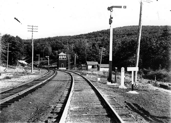
This photo of the North Portal approach and Mamakating Tower in happier days shows the extensive infrastructure mandated by continued operations through the Shawangunk bore, all to insure the safety of trains operating in both directions through the single track portion of the Mainline route.
I’m never quite sure of the particular reason for a fascination with any specific part or portion of the O&W, but I can certainly say that High View Tunnel holds that status; -- of immense fascination. I’m certain that this is shared by many others in the legion of O&W enthusiasts. However it came to be, and maybe it’s that the North Portal was one of the very first of the many O&W venues that I ever visited, that fascination draws me to back to the place whenever the opportunity arises.
Most recently, both Ron Vassallo and myself had been the recipients of E-mails from an engineer working for the New York Highway Department who made inquiries about the tunnel and its interior. Apparently there is some engineering concern about the tunnel bore and its location beneath Route 17; -- all as Route 17 is to undergo the improvements needed to make it a part of the Federal Highway system, now as Route I-86. Whereas the open bore of High View tunnel passes beneath the roadway the engineering concern is of ground subsidence, or collapse, due to cave in in the interior of the tunnel bore.
This concern has
been partially addressed by engineering proposals for the exit ramp and
roadway that will be located directly over the tunnel bore, to be reinforced
with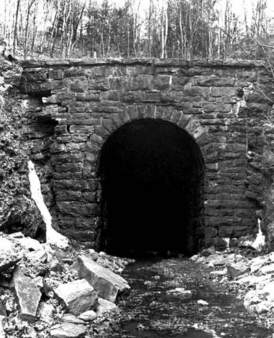 structural steel and concrete. This would support the exit ramp above should
ever the tunnel bore collapse beneath. Nevertheless, the condition of the
bore was then, and is still of concern to the civil engineers involved.
structural steel and concrete. This would support the exit ramp above should
ever the tunnel bore collapse beneath. Nevertheless, the condition of the
bore was then, and is still of concern to the civil engineers involved.
Right Photo: An early 1970s view of the masonry North Portal shows already some deterioration has taken place. The “weeper” pipes and outlet on the upper left side of the portal have already been broken away in the recurring seasonal cycle of freezing and thawing. Some of the stone blocks have been dislocated and fallen away, leading further down the road to a collapse of the stonework of the Portal structure.
Our incoming E-mails explained to both Ron and myself, an interesting feature of the legal status of the High View Tunnel. Inferentially, the “New” Route 17 was being planned even before the O&W was abandoned (thereby somewhat belying the commonly held notion that “the State” then “wanted” the O&W abandoned so the Highway Department could utilize the Right-of-Way to lay out the new highway). In this pre-abandonment planning the Highway Department secured a legal easement, interestingly enough, down, over and through a portion of the area of the North Portal. This was to allow a periodic inspection of the Portal and bore by the Highway Department; -- again, and even at that time, to insure that collapse and ground subsidence were not under way.
Ron and I were informed that this easement dates back to early 1956 and further that it requires the maintenance of railroad clearances through the tunnel bore! We also learned that the New York conservation Department considers the High View Tunnel bore to be a watercourse(!), of all things. These snippets of information are all the more interesting as they too seem to contradict common notions about the run up to, and ultimate abandonment, of the O&W and the idea that the ROW was so coveted by other agencies for other than railroad purposes.
Some years back there was an attempt to seal off the North end of the tunnel by some man made methods. Ron, whose youthful fascination with High View and environs dates back to family camping trips to the Summitville-Mamakating - Wurstboro area, testifies that a local contactor was hired, by whom is not exactly known, to gnaw away at the roof of the tunnel and portal with a large back hoe excavator and cave a portion of it in upon itself. This was all apparently undertaken and arranged for after a person drowned inside the bore, in a pool of water captured on the floor of the tunnel. While it is that the lands though the tunnel bore and the ROW to the north are in private ownership, and since it is not clear to this writer that the circumstances of the drowning and the later excavation work compelled either landowners or local agencies to attempt a closure of the Portal, the fact remains that it was tried (badly, in my opinion) and then served only to capture and trap additional standing water on the floor of the tunnel.
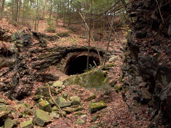
Blocked portal
This is the more recent view of the North Portal as partially blocked by the excavation work from years back. A close inspection of the debris revealed that the original portal, as evidenced by an untouched footing block was immediately to the lower left of this view (Photo Below). This gives a good indication of the not insubstantial length of the bore, perhaps as much as twenty feet, that was collapsed and excavated in the attempt to shut off access.
As an aside, it must be understood that sound tunnel engineering places a tunnel bore at a “summit.” Whether it is for highway, railroad or other purposes, the most economically built tunnel is the shortest possible tunnel. Therefore the route and approach leading to a tunnel bore must climb, climb, climb, and climb some more, until it can go no further without boring a tunnel. That necessary “climb” ideally must occur on both approaches to a tunnel bore, but even in the case where a tunnel may be one of a series of tunnels on an upgrade (as is [was] the case with the Ute Pass series of tunnels on the Colorado Midland) there must be “crest” in, at the entrance of, or within a tunnel in order to drain water run off from the bore.
In the case of High View Tunnel, the crest of the grade was just inside the South Portal. After negotiating the approach and the shallow left curve inside the rock south Portal, the High View Tunnel alignment was ever so slightly downgrade, heading north. This means that the blockage of the North Portal trapped considerable water within, emanating from the springs, seepage and weeping of Niagara Escarpment type shale of the Shawangunk Ridge within; -- to a sounding of perhaps as much a six feet, at the man made dike blocking the North Portal.
Last July engineers and geologists from the New York Highway Department inspected a portion of the High View Tunnel bore. Not wanting to enter across private lands they rappelled down the steep slope above, from the edge of Route 17! I had informed our engineering correspondent that, based upon a number of walking trips of my own during the 1970s and 1980s that there were three sections of brick liner spaced irregularly through the bore. From the North Portal there was a section of liner, which then terminated and opened up into a large “room” solely of rock bore construction. The rock bore was considerably larger than need for clearance, and the bore proceeded to another section of liner. There was a masonry interior portal and then an arched brick lined section meeting only the clearances of AAR Plate C. Inside the liner section were arched vertical “manholes” set into the sides of the liner; -- in similar fashion to those found in subway tunnels to allow a worker within to stand back and essentially make himself flush with the liner wall to avoid injury from a passing train. There was yet a third liner section of the same construction; -- each with masonry portals at either end, and buttressed by the large rock bore “rooms” I described before.
In traversing the tunnel, and despite that there’d been no passage of steam locomotives since 1947-1948, it was very interesting to find heavy layers of soot and cinders on any and every surface even resembling horizontal. The rough walls of the rock bore sections of High View Tunnel had many small protrusions, bumps and divots which easily held the deposits of soot. The entirety of the bore was coated with soot blasted by passing locomotives onto the roof of the tunnel, except in those locations where rock had fallen from the tunnel roof, or had been rinsed away by the multitude of water streams from underground springs that exited into the bore.
I reported this to our E-mail correspondents, and cautioned that there was a huge rock fall in nearly the center of the tunnel bore; -- easily identified by first looking to the top of the tunnel and finding a bright “clean” area lacking any of the patina of soot. This rock fall, perhaps made during the earlier initial construction of Route 17, is so large as to nearly block passage by and beyond it, though on a trip when the condition was not so nearly deteriorated I’d noticed off-road vehicle tire tracks on the floor of the tunnel, and just barely making it past this largest of rock falls.
The engineers and geologists from the Highway Department ventured into the tunnel bore only about as far as the large rock fall in the center, but then had learned all they needed to know. Evidently the geologists were of the opinion that the standing water in the tunnel would hasten the further deterioration of the rock bore [and thereby increase the likelihood of additional rock falls and subsidence above the line of the tunnel bore]. The determination was made that the interior of the tunnel had to be “de-watered.” This was scheduled to take place sometime in July or August of this year.
Having been to the North portal long before its collapse and destruction, and then afterwards, I’d noticed that the original footings for the masonry portal were still in view, then suggesting that the excavation work had only collapsed the portal and a portion of the tunnel roof and immediate lining in onto itself; -- so to speak. I could further assume, from the several trips and observations I’d made that perhaps the date block was buried somewhere in the rubble. I’d doubted that it’d ever been retrieved………
Through and around a couple of E-Mails, some additional information about the dewatering plan emerged. The Highway Department intended to run some excavating machinery in the old ROW, from “Old 17” and gnaw away at the rubble pile blocking the entrance to the North portal and from the water dam at the mouth. I inquired about retrieval of the date block; it then being the only significant historical remnant that might be rediscovered during this process. Ron and Trustee Chairman Joe Bux agreed that it might be worthwhile to save the date block, so a further inquiry was made.
The Highway Department folks, though a tiny bit concerned about who actually might be the owner of such a thing, would set the date block aside if they found it. However, and whereas theirs was purely an industrial and engineering undertaking, the dewatering excavation wouldn’t be a part of any effort to preserve any archeological remnant. Furthermore, a larger question loomed in the form of what exactly and new custodian would actually do with a stone block weighing, perhaps, in the vicinity of 3,000 pounds, or even more! Even more importantly, “we” (OWRHS) would have to coordinate to the extent that once found the chore of removing the date block from the site was only ours, and we’d have to do it, and get it out on the day when it was actually uncovered.
Not having any place to put this immense thing, not any notion of where and to whom it might be donated for preservation, a “temporary plan” was hatched. Member Charlie Breiner lives up in Claryville, not but a dozen miles (and “change”) away, and he agreed to plunk it down someplace on his land out of the way……………for a while. Charlie’s neighbor, Tom Matthews had a truck suitable for hauling the stone away, and would surely help in this part of the endeavor.
Alas, despite some inquiry and maybe even the formulation of a plan as described, all went for naught. The dewatering schedule, no doubt governed by the availability of contractors, had to move forward; -- the work was done but the date block was never recovered. Now, since “fair is fair” that didn’t trouble us……….really. These guys who had to do their jobs weren’t really charged with looking for artifacts, nor were they under any obligation fir anything beyond the engineering necessities. The editorial “We” consisting of Ron and I, if we may all take credit) really “insinuated” ourselves into this entire procedure by raising the question in the first place. It’d all started with an innocent inquiry about the tunnel proper, and “we” came to be slightly privy to probably much more than we were entitled.
Besides, the odds of even finding a date block, and not knowing the extent of damage it might’ve suffered when the whole of the Portal was pulled down, much less even finding it, were not good. It would’ve only been an interesting find……if at all. So far as it went, the tale of even getting this far, must now become a new tiny part of O&W and OWRHS lore. That’s enough…………..
To finish, the work was done and the tunnel bore was dewatered. While it is by no means restored, in any sense of the word, the North Portal of the High View Tunnel again resembles more what it was supposed to be. Ron had gotten an E-mail image from another O&W enthusiast sometime at the end of August that showed the open and dewatered bore and North Portal. The photo was posted to the OWRHS Website, but from my walk in the weekend of the 2006 Convention, here’s a few more pictures with some captions………….
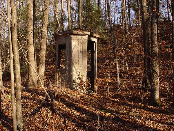
Walking in, one of the first of the old O&W “Artifacts” to be seen ins the C.F. Massey Company manufactured cast concrete telephone booth. The Massey firm, based in Chicago, manufactured these enclosures for any number of purposes; -- Telephone booths, outhouses, watch shanties, and oil storage sheds. The simplicity of the design and complete manufacture was that they could be transported and put in place very rapidly and conveniently. Close by this enclosure are still extant footings for signals and battery wells for power to the signals. After the closure and removal of Mamakating Tower and train Southbound might be required to stop upon the stop aspect and indication of the signal. The nearby [railroad only] phone booth would allow an engineman to call the Dispatcher to learn the nature of the delay and stop indication; -- or to report a signal malfunction if that turned out the case.
An interesting note here
is that [timetable] westerly of this location is a new home situated on the
regraded slope below the ROW. It appears that considerable earth was moved,
since this was the historic location for the “spoil” dump from the original
excavation of the tunnel bore. While I don’t know who owns the immediate or
adjacent lands, some courtesy may be in order for any others who
should venture in on foot to visit the North Portal. This’s no longer quite
so forlorn, remote, and isolated an area, and there easily could be concerns
now, by the new residents, for the explorers and railroad archeologists now
walking quite so close to backyards.
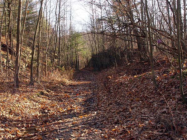
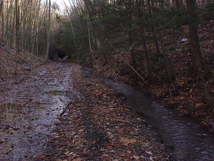
This shot is taken walking into the cut as the ROW curves to the East running down towards Mamakating. The track alignment and ROW changed direction significantly at this location, marking out nearly a full right hand turn to start the grade descent to Mamakating and then down to Summitville.
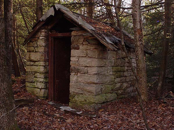
The only structural artifact remaining hard by the former location of Mamakating Tower is this stone magazine. This tiny building was evidently used for the “day storage” of explosives, either in the original construction of the Tunnel [most likely], or for later use to clear large rock falls [doubtful]. The stone construction of the walls and steel entrance door would contain an accidental explosion, while the light construction of the roof would focus a blast an debris upwards. The modest roof could be easily and inexpensively replaced if destroyed in a blast, and the immediate area and workers would be protected form injury by the stout construct of the magazine.
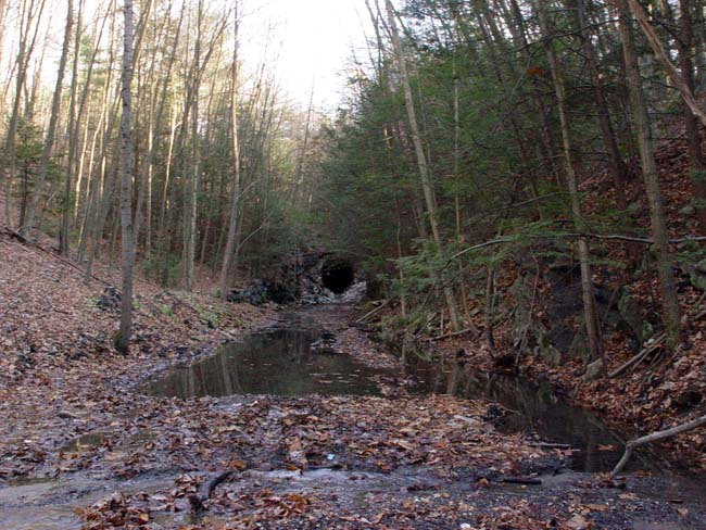
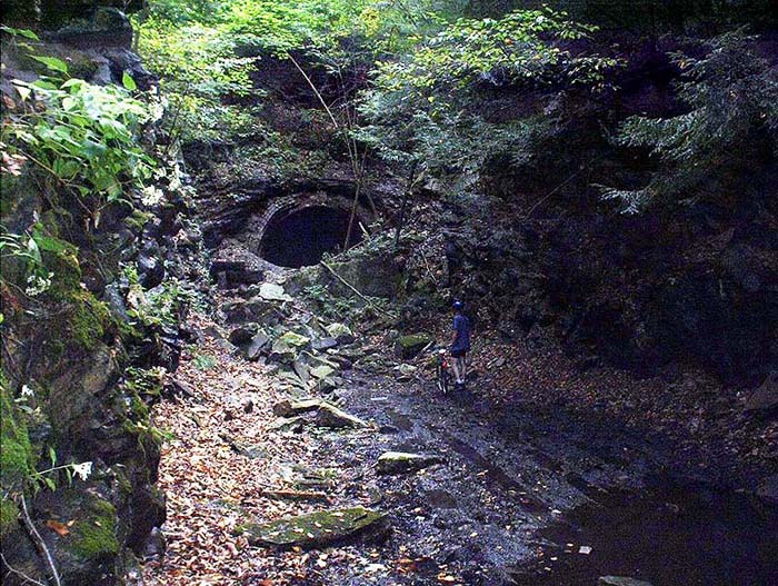
Approaching the bore, this’s the first view of the reclaimed area that an explorer and hiker will see. The water flow, from both the tunnel bore and surrounding runoff, in this area is extensive, so (contrary to my own preparations for this visit) good high boots are in order.
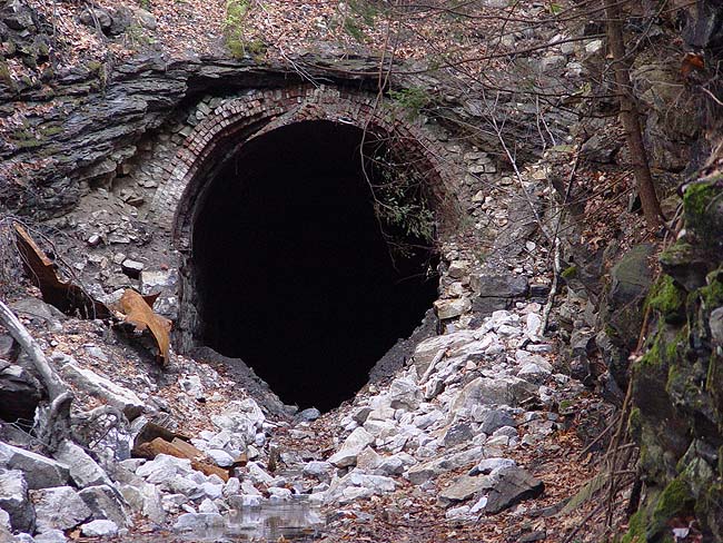
This is the “new” North Portal of High View Tunnel as is appears now after the dewatering excavation undertaken by the Highway Department contractors. This was about as close as I could get on this trip, since the recent excavation has well disturbed the roadbed and ground. The top layer of soil is little more than mud and muck and, being unprepared for this while further recalling the historic stability and pack of the former roadbed from prior visits, I got an entire shoe full of mud and muck when stepping into a miniature sinkhole that was well disguised by new fallen leaves.
In retreat, this last photo shows the run and flow of water from both the Tunnel bore and the veritable stream running down the east side of the approach cut. There has always been a significant water flow from the Tunnel and in the post abandonment years much of it stood directly in the ROW. It could be that the recent dewatering excavations also created a more discrete channel for water flow, seen here to the right of the photo, since that appears to be something new………or at least improved.
Mal Houck 11/17/2006
UPDATE 12/06: It has been a few years
since I was last up to the tunnel. When I heard about the reopening of the
portal I had to come back. Having survived the downhill u-turn at the old
overpass, my friend Irene and I set out with out high boots (it pays to
listen) and our high tech camera equipment-two throwaway cameras, one color,
one B&W.
Now I was the one making the noises about not going into the
tunnel, treating it with respect. But in reflection, the depth of the (very)
cold water was probably the only thing keeping me honest here and only going
about ten feet before the water came over the tops of my boots. I have
walked through the railroad tunnel at West Point but there was no feeling of
awe for the handwork like one feels here. We moved as many stones out as
we could and the water came out in a giant swath but there is still more
work to be done there. Anyone for pick and shovel crew-you have two willing
hands here!
It was Irene on the trip up that spotted the plaque on the
ground . On the return trip we made good on a promise to fix it. The man in
the local hardware store was nice enough to cut and drill on the spur of the
moment two pieces of plexiglass. So with our plaque sandwich back to the
mountain we went.
As we were leaving I could not help but feel we were leaving
a very peaceful place. The distant noises of the highway no less intrusive
than the trains once were. The buildings and track are gone of course, and
nature in time will do what it's gotta do. If anyone believes in the after
life than this piece of the old woman is slipping away from us to a place
where an O and W section gang awaits-patiently. Robert McCue
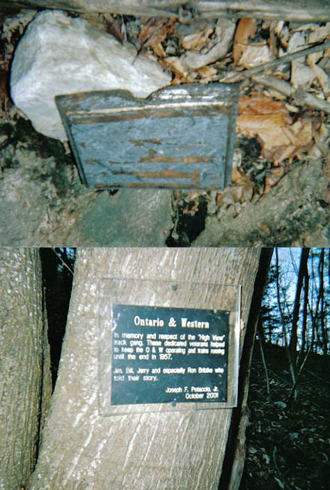
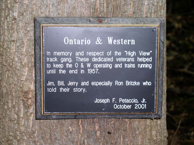
Original Tribute Donated By O&WRHS Member Joe Petaccio
Related Article: An Afternoon Visit With The Old Woman by Ronald J. Vassallo