Noted Author, Rail Historian and friend Robert E. Mohowski awakens the spirit of the O&W.
An Afternoon Visit With The Old Woman
by Ronald J. Vassallo
On a hot day in early June of this year, Bob Mohowski and myself decided to head up to Orange County for an O&WRHS business meeting a little early, to head off road and see some things that are off the beaten path. One wonderful thing about the O&W is you really don't have to travel as far as one might think to see a bit of rail history. That is if you know where to look. The area we targeted happens to be one of favorite places on O&W in Wurtsboro and Summitville NY.
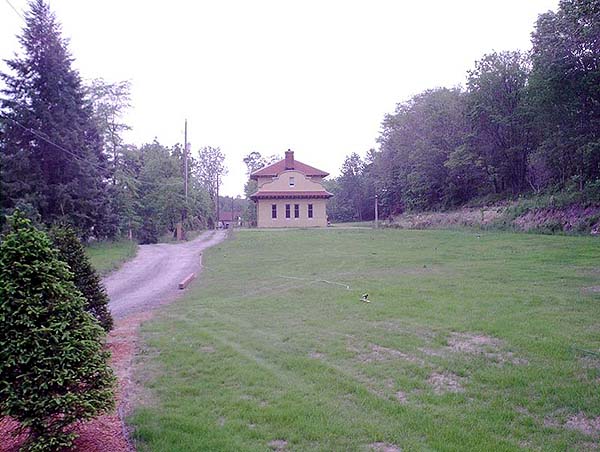
Bob and I only had about an hour as a severe storm front was moving in so I decided to make a quick stop at the Highview Depot. The new owner has done an awesome job of revamping the station and now uses it as a private residence. I hear is is railfan friendly but we did intrude on him or his family and I am sure he would appreciate the same from others. Again this is private property and I know that some of us, myself included, have been spoiled by being able to drive right up to the depot and walk to the south portal of the tunnel, but this is now fenced off and part of his property. Bob and I stood by the fence line and were able to enjoy a splendid view without having to intrude and there were many items of interest, some original to the property and the O&W still in full sight.
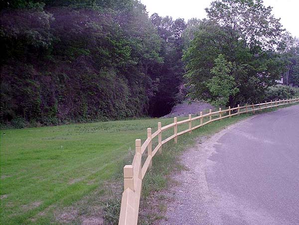
After catching our breath from the ride up we proceeded to Wurtsboro and around the "hairpin" curve when I cautioned Bob to hold on tight as we made a quick left off of old 17 and on to O&W roadbed! After passing an old octagonal concrete workmans shanty and a few concrete semaphore and signal foundations the air grew cooler and the walls of the forest grew steeper and we both knew we were getting close to the north portal of the Tunnel. We were both amazed by how much of the ties are still scattered around the roadbed and in some places they were left in place so you can make out the actual placement of the tracks.
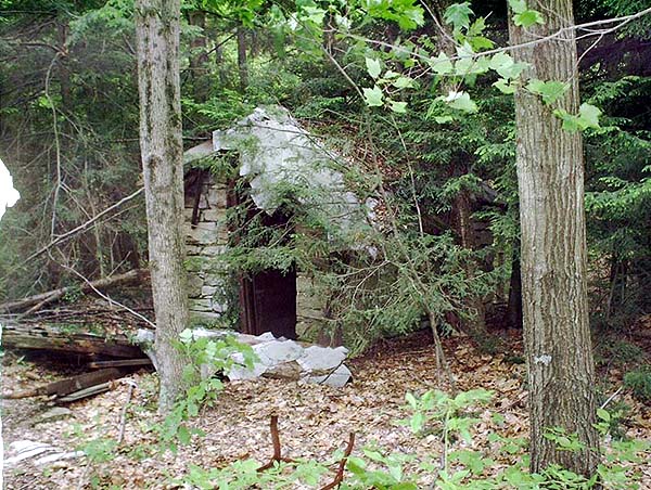
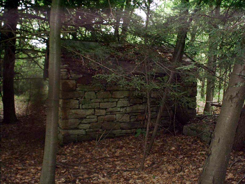
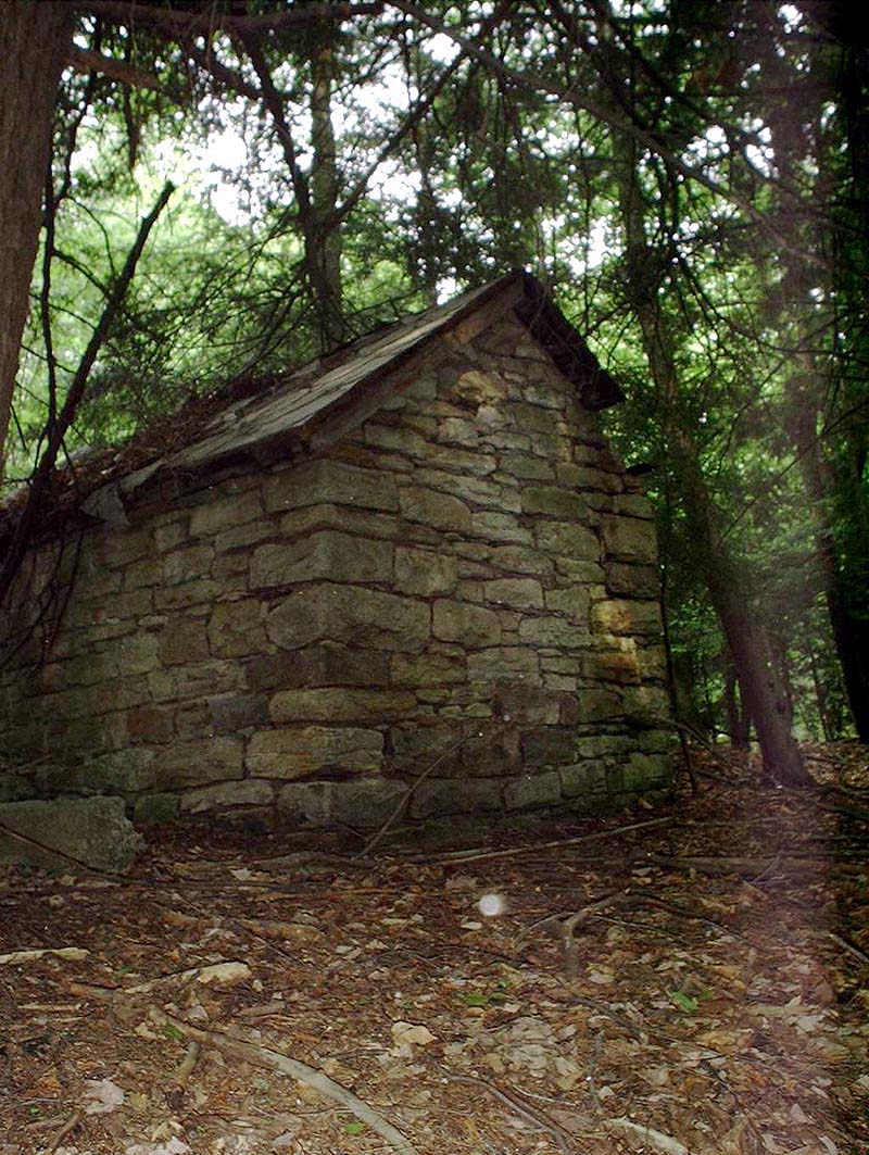
Before we made it to the tunnel I made a stop at a little structure that has intrigued me for many years and I had actually forgotten about it until I made a trip to the same area last summer with fellow member John Pavelchak. If any of you have a definitive answer on what this structure was please let me know but to the best of our knowledge this was used as a retreat building ( Photo 2, Photo 3 ) when they were blasting large pieces of rock that were brought out from the Highview tunnel and were too big to be taken away in one piece. Bob has suggested that they would dynamite them into smaller pieces and then perhaps lift them by crane and put them in a gondola to be taken away, perhaps for fill in another location on the O&W.
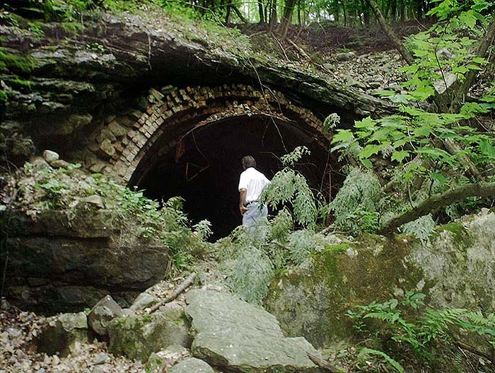
A few minutes and a short walk through lots of water and mud. Yes! Now we definitely knew we were on the O&W, we came to the north portal. The local municipality has attempted to close in this side of the tunnel but it seems the local folk have a different idea about things. I have heard that there was a drowning in the tunnel a few years ago so you can't blame them. Please use the utmost caution and respect when exploring places like these and never go alone. With that said and done we both eagerly made our way to the entrance and were surprised at what could be seen. As shown in the header photo for this page it is remarkable that the brickwork and the metal lining are still visible. Bob made a good point when he raised the question as to how they actually put that in place and what kind of form or method was used to get that bricks laid in four layers. The craftsmanship of the O&W builders still shines through after all these years. Another observation of interest is the unusual color of the water inside the tunnel which is a bout 2-3 feet at the entrance. It is a beautiful mixture of blue-green-gray and is said to be the result of the water draining through the layers of mineral rich rock.
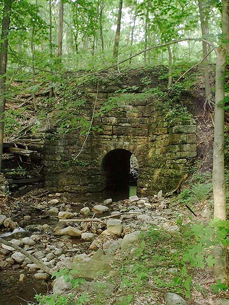
With the clock ticking away we got back in the Jeep and started to make our way down towards Summitville stopping briefly to take a look at the Mamakating Depot. The roadbed from the Mamakating to Summitville is in remarkable shape and again there are many ties on both sides. Nothing can beat the smell of fresh country air and O&W cinders and we were enveloped by both. We made it to Summitville in no time at all and made our way down to the old mining pit or as we used to call it the "sand pits" and stopped for a cool drink from a mountain stream being fed through this incredible O&W stone culvert. As Bob and I stood there taking in this piece of engineering little did we realize that a swarm of mosquitoes was taking us in! We're outta here!!!
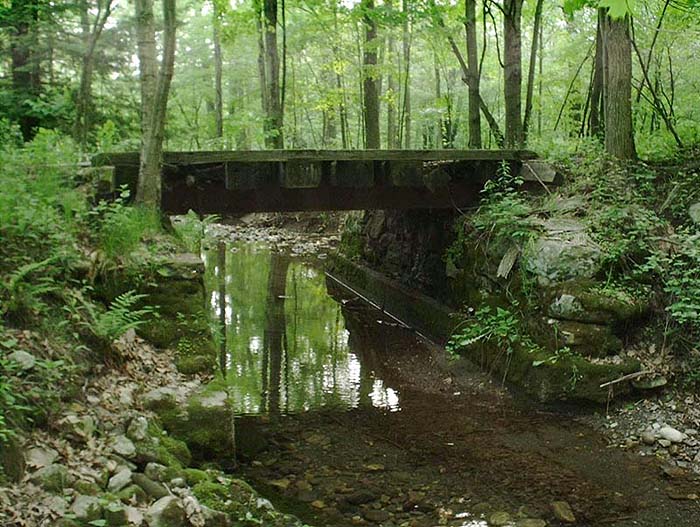
We did not make it to the area of the Summitville station (There is nothing there any more except a few concrete foundations for the water cranes and such) but instead made a detour on to the Port Jervis branch and down the branch back towards Wurtsboro. With the picturesque Delaware & Hudson canal following us on the right hand side one couldn't help but wonder what it must of looked like in the day complete with mule on the towpath and barge in tow. I couldn't resist stopping again and taking a photo of what I feel are some of the most unique bridges on the O&W. These steel I-beam and wood bridges are ingenious pieces of bridgework which I chalk up to clever thinking and a strict budget in the O&W's engineering department. As far as I know there were not too many of these types of bridges on the O&W and most of them were on this branch. There are at least two of them between Summitville and Wurtsboro.
Almost out of time a with the sky blackening we made one last stop at the "Lead mine" to walk around the foundation of the Mining facility and look for some unusual rock specimens. Fools gold is plentiful and if you have the patience you can come away with some nice quartz embedded rocks as well as individual crystals. I can't help but sense the feeling of being watched when I am at this specific place and if you have read the article about the Mamakating Mine on this site you will know why. Longtime O&WRHS member Herb Heidt once told me that this mine was used for two World Wars and if my memory serves me well there was an unsuccessful attempt to start a mining operation there again in the early 70's. As we moved out along the old right-of-way and and concluded our day I felt the way you do when two old friends are reunited. Although I don't get to make this pilgrimage too often any more when I do it is fulfilling. It was the beauty of the countryside which first attracted my family to camp this area some thirty years ago and it is the same feeling that brings me back today.
A few days after writing this article longtime O&W fan Mal Houck sent me this e-mail which I thought you might find as interesting as I did. I have published this in it's entirety with Mal's permission.
Ron:
I read with interest your account of the brief visit you and Bob Mohowski made to High View, and the North portal of the tunnel. I first visited the North portal only a little more than a dozen years after the road quit, and both your narrative and included pictures show many changes since that time and when I was last there in the late 80's. Notably, it appears that much of the portal retaining wall has either collapsed, or has been demolished in the attempts to close off the entrance. By the late 70's stones were tumbling down from the left side of the portal, but the "date block" was still in place and clearly legible.
I have several comments on this area, and I think I can answer your question about the odd stone building (timetable) north of the tunnel on the North (compass) side of the right of way. While it may seem at first that this building was a "retreat," that is where tunnel workers would take shelter from debris during blasting, I think it may not be so.
First, the entrance is facing south, towards the tunnel entrance, or any prospective work area. A retreat truly should have its entrance facing away from the most likely blast area. Secondly, the roof structure is far too flimsy to afford any protection from blasting debris that might fall in the area. A retreat would more likely have a flat roof made of heavy timbers, earthen packing, another layer of timber at right angle to the first, and topped by another layer of earth and soil. Also, while this structure is some distance from the portal, it stands proud from the grade elevation, whereas a retreat would be built more like a bunker, and cut into the side of the embankment.
Now while none of what I offer here is based upon any data or records, I have visited this site many times and I have taken many pictures of what remnants then remained. Based on what I have seen, I think the "Mystery Building" is a magazine, for the storage of explosives. There's several things that lead me to this conclusion, and to some large degree, that it looks particularly like buildings I know to be explosives storage magazines.
The Maynard, Massachusetts area, where I live, was, through the larger part of the first half of this century, a major center for the manufacture of explosives. The nearby WR Grace plant was originally an American Cyanamid plant for the production of nitroglycerine, and later the manufacture of guncotton and "flashless" powder during the First World War. The main road into Town, from Concord, Mass. is known as Powder Mill Road, and as it passes from Acton to Maynard it passes beside what is known as Magazine Hill, where there are still explosives magazines in use. Right near the road, by a former powder mill, is an above ground magazine, used until recently by Barclay Explosives, of Needham, Mass. for da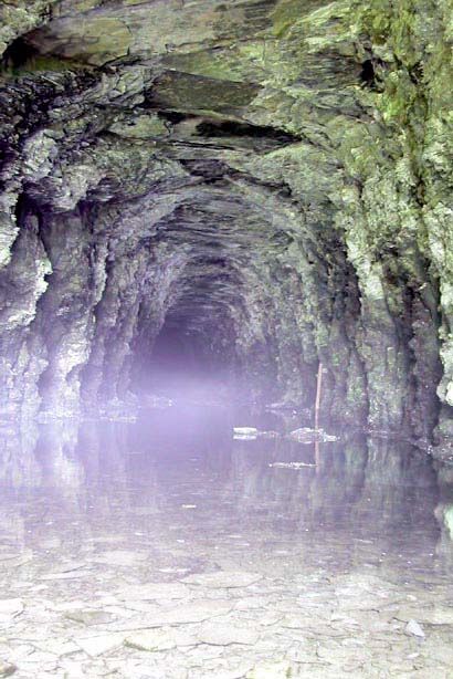 y storage. This old magazine ears an uncanny and strong resemblance to the High View Tunnel Mystery Building.
Aside from the similarity of the mystery building to what I know elsewhere to be magazines, its construction is completely in order for its use as a magazine. It is somewhat remote from the area where explosives would be needed (the tunnel, as under construction), but not far enough away to be inconvenient. The substantial stone walls would contain an explosion and direct it upwards. The roof, being lightly constructed, would not contain an explosion to an extent likely to severely damage the walls, and would likely just be blown away. A post-explosion repair would then only involve replacement or repair of the roof. I also recall that the door, facing the tunnel portal, both opened inward and was made of steel or iron, which is also a design feature consistent with powder magazines of the era.
I've always suspected that the magazine, if this is what it is, was built as the tunnel was being constructed. It could have then been kept and used at least for day storage of explosives if blasting was later needed to clear tunnel falls or, as Bob suggested, to reduce larger pieces of falls. I also recall seeing, with some interest at the time, at least two narrow ridges falling off to the side of the embankment, beyond the magazine towards Wurtsboro. Though they were too overgrown to really determine what they were, I always thought they were too linear to be natural occurrences. I've always wondered if they might have been dumps for some of the spoil from the tunnel excavation.
You also mentioned the little concrete octagonal "toolshed" to the left of the access road heading from Old 17 to the portal, which I think might have been an outhouse for the use of the towermen at WX. I never approached it that close, or looked inside, but, with the window cast in the wall, it sure looks like an old Archive Reprint that Joe Bux once dug out.
You mentioned in your piece that Bob marveled at the construction of the liner at the North Portal, but that's not even the half of it. Once while on an O&W exploration trip with another friend, we had stopped up at Wake's new contemporary house in Grahamsville, and we were chatting and swapping fibs when the subject of High View Tunnel came up. Wake's book was in recent publication and had shown an engineering drawing of a liner in the interior of the tunnel, and he graciously shared with us copies of the prints he used in the book. When we let on that a thorough inspection of the tunnel, while not admitting to any venture through it, was a featured reason of this particular trip, we tried to get him to pack up and go along. He had to decline, due a prior dinner engagement, but promised to go again, another time. Unfortunately, that was the last time I saw him, but the intended visit was on anyway.
Now while not clearly admitting that I ever did walk through the tunnel, you can be advised that there is not one but three sections of liner within, two beyond the portion that was framed by the North Portal. Evidently there was more than one unstable section of the bore. Proceeding south one would have the outline of the North Portal to the rear, and only darkness ahead, due to the curve at the South Portal. I have it on good advice that the tunnel was regularly used for ATV and Jeep traffic, with tire tracks clearly in evidence. The "rooms" between the liner sections could seem, to one who would walk through the tunnel, to be cavernous. Each section of liner is faced with a portal, north and south, then lined at a clearance probably resembling "Plate C," but at close enough clearances so that there are "manholes" in the masonry to allow a tunnel worker to stand clear of a passing train. Now if someone actually did walk through the tunnel, say more than twenty-five years ago, it could have been reported that much of the roadbed was in almost an excellent condition, with ties removed, and a fairly firm gravel footing. If one could have actually seen all of this, it could only add to the marvel of what the original Midland engineers carved of this mountain.
Mal Houck
Photo Middle Right: View of the interior of the O&W Highview Tunnel taken from just inside the south portal, July 24, 1999. Surprisingly vividly-colored mineralization of the upper walls and roof is shown. The tunnel is partly water-filled at the south end, here to a depth of inches but reportedly it was under six feet of water nearer the Wurtsboro portal. A red marker stick appears at right in the distance; this may be used to give observers some idea of the water's depth. No evidence of any form of lining material appears at this end of the tunnel. Taken with a Canon Powershot Pro70 digital camera and Canon Speedlight 380EX. Photo and caption by Seth Lewin.